Geolocate

Piha topographic map

Click on the map to display elevation.

About this map

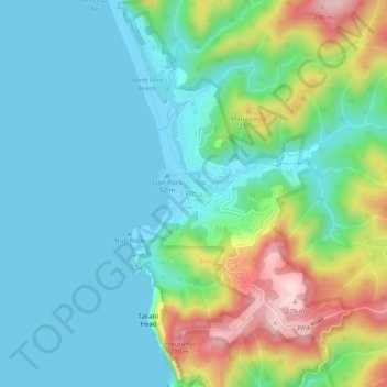
Name: Piha topographic map, elevation, terrain.

Location: Piha, Waitākere Ranges, Auckland, 0772, New Zealand (-36.97555 174.45009 -36.93555 174.49009)

Average elevation: 77 m

Minimum elevation: 0 m

Maximum elevation: 283 m

Other topographic maps

Click on a map to view its topography, its elevation and its terrain.

Mauku

New Zealand > Auckland > Waitākere Ranges

Average elevation: 86 m

Gear up for your next adventure:

🪑Ultralight Camping Stool - Compact seating for rest stops during long hikes
🧥Softshell Jacket - Windproof and breathable jacket for hiking
🥾Trail Hiking Socks - Comfortable socks to prevent blisters and fatigue
🧴Waterproofing Spray - Restore the DWR coating on jackets and tents
🔨Vehicle Emergency Tool - Safety tool for remote road trips to trailheads

As an Amazon Associate, this site earns from qualifying purchases at no extra cost to you.