
Thank you for supporting this site ❤️
Make a donation
Make a donation
Gear up for your next adventure:
As an Amazon Associate, this site earns from qualifying purchases at no extra cost to you.
Chesterfield topographic map
Click on the map to display elevation.
Thank you for supporting this site ❤️
Make a donation
Make a donation
Gear up for your next adventure:
As an Amazon Associate, this site earns from qualifying purchases at no extra cost to you.
About this map
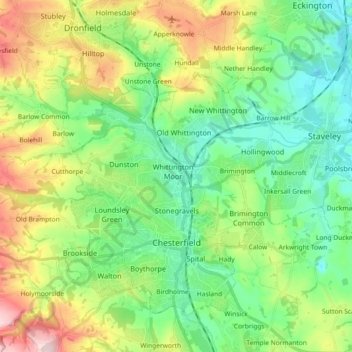
Name: Chesterfield topographic map, elevation, terrain.
Location: Chesterfield, Derbyshire, England, United Kingdom (53.21242 -1.48429 53.29903 -1.30130)
Average elevation: 127 m
Minimum elevation: 41 m
Maximum elevation: 305 m
Thank you for supporting this site ❤️
Make a donation
Make a donation
Gear up for your next adventure:
As an Amazon Associate, this site earns from qualifying purchases at no extra cost to you.
Other topographic maps
Click on a map to view its topography, its elevation and its terrain.
Sawmills
United Kingdom > England > Derbyshire > Amber Valley > Ripley > Fritchley
Average elevation: 119 m