Geolocate

Lumbangan topographic map

Click on the map to display elevation.

About this map

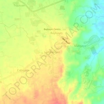
Name: Lumbangan topographic map, elevation, terrain.

Location: Lumbangan, Rosario, Batangas, Calabarzon, 4225, Philippines (13.79665 121.24048 13.83665 121.28048)

Average elevation: 127 m

Minimum elevation: 92 m

Maximum elevation: 157 m

Other topographic maps

Click on a map to view its topography, its elevation and its terrain.

Pinagsibaan

Philippines > Batangas > Rosario

Average elevation: 57 m

Gear up for your next adventure:

🧭GPS Handheld Device - Reliable GPS navigation for outdoor adventures
🥾Mountaineering Boots - Supportive boots for climbing and high-altitude hiking
🔥Camping Stove - Portable stoves to cook outdoors with ease
🧳Compression Sacks - Maximize space in your backpack by shrinking gear
🛶Canoe Life Vest - Safety vest for water sports

As an Amazon Associate, this site earns from qualifying purchases at no extra cost to you.