
Make a donation
Gear up for your next adventure:
As an Amazon Associate, this site earns from qualifying purchases at no extra cost to you.
Abrantes topographic map
Click on the map to display elevation.
Make a donation
Gear up for your next adventure:
As an Amazon Associate, this site earns from qualifying purchases at no extra cost to you.
Abrantes
An active republican center, Abrantes was the place of preparatory meetings for the 5 October 1910 Revolution, which may have contributed to the village's elevation to the status of city on 14 June 1916.
Make a donation
Gear up for your next adventure:
As an Amazon Associate, this site earns from qualifying purchases at no extra cost to you.
About this map
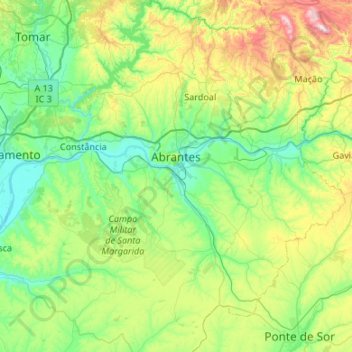
Name: Abrantes topographic map, elevation, terrain.
Location: Abrantes, Santarém, Portugal (39.23331 -8.35557 39.64649 -7.93946)
Average elevation: 167 m
Minimum elevation: 9 m
Maximum elevation: 636 m
Make a donation
Gear up for your next adventure:
As an Amazon Associate, this site earns from qualifying purchases at no extra cost to you.