Geolocate

Andretta topographic map

Click on the map to display elevation.

About this map

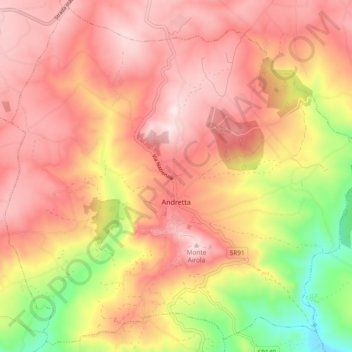
Name: Andretta topographic map, elevation, terrain.

Location: Andretta, Avellino, Campania, Italy (40.90979 15.28225 40.97757 15.37564)

Average elevation: 727 m

Minimum elevation: 436 m

Maximum elevation: 905 m

Gear up for your next adventure:

🥾Hiking Boots - Sturdy boots providing ankle support and traction on rugged trails
📷Outdoor Action Camera - Capture high-elevation views and rugged adventures
🥾Lightweight Hiking Shoes - Comfortable shoes for day hikes
Camping Coffee Maker - Brew fresh coffee anywhere on the topographic map
🥾Trail Hiking Shoes - Durable shoes designed for rugged trails

As an Amazon Associate, this site earns from qualifying purchases at no extra cost to you.