
Make a donation
Gear up for your next adventure:
As an Amazon Associate, this site earns from qualifying purchases at no extra cost to you.
Lac Marchand topographic map
Click on the map to display elevation.
Make a donation
Gear up for your next adventure:
As an Amazon Associate, this site earns from qualifying purchases at no extra cost to you.
About this map
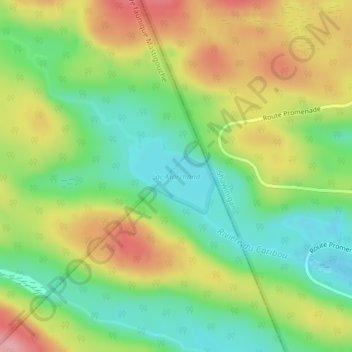
Name: Lac Marchand topographic map, elevation, terrain.
Average elevation: 367 m
Minimum elevation: 308 m
Maximum elevation: 444 m
Make a donation
Gear up for your next adventure:
As an Amazon Associate, this site earns from qualifying purchases at no extra cost to you.
Other topographic maps
Click on a map to view its topography, its elevation and its terrain.
Dûché de Bicolline
Canada > Québec > Maskinongé (MRC) > Saint-Mathieu-du-Parc
Average elevation: 214 m
Lac à la Pêche
Canada > Québec > Maskinongé (MRC) > Saint-Mathieu-du-Parc > La Pointe-aux-Tremblay
Average elevation: 216 m
Make a donation
Gear up for your next adventure:
As an Amazon Associate, this site earns from qualifying purchases at no extra cost to you.
Rivière Shawinigan
Canada > Québec > Maskinongé (MRC) > Saint-Mathieu-du-Parc
Average elevation: 236 m