Geolocate

Bauan topographic map

Click on the map to display elevation.

About this map

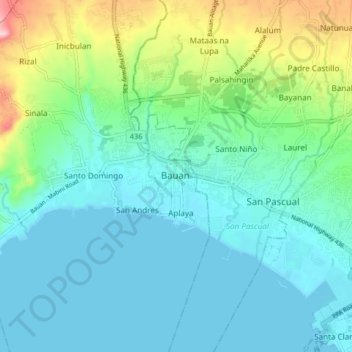
Name: Bauan topographic map, elevation, terrain.

Location: Bauan, Batangas, Calabarzon, 4201, Philippines (13.75014 120.96769 13.83014 121.04769)

Average elevation: 46 m

Minimum elevation: 0 m

Maximum elevation: 214 m

Other topographic maps

Click on a map to view its topography, its elevation and its terrain.

Manghinao River

Philippines > Batangas > Bauan > San Andres

Average elevation: 25 m

Catalina Lake

Philippines > Batangas > Bauan

Average elevation: 85 m

Gear up for your next adventure:

🥾Waterproof Hiking Boots - Essential footwear for rugged terrain and wet Canadian trails
🎒Backpack Rain Cover - External shield to keep your entire pack dry
🦟Insect Repellent - Keep mosquitoes and black flies away in wooded areas
🥾Lightweight Hiking Shoes - Comfortable shoes for day hikes
🦌Outdoor Trail Camera - Monitor wildlife activity near your favorite spots

As an Amazon Associate, this site earns from qualifying purchases at no extra cost to you.