
Saint-Laurent-d'Aigouze topographic map
Interactive map
Click on the map to display elevation.
About this map
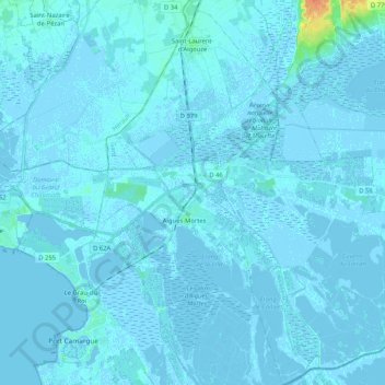
Name: Saint-Laurent-d'Aigouze topographic map, elevation, terrain.
Average elevation: 1 m
Minimum elevation: -5 m
Maximum elevation: 34 m
Other topographic maps
Click on a map to view its topography, its elevation and its terrain.
Clos des Siffleurs
France > Occitania > Saint-Laurent-d'Aigouze
Clos des Siffleurs, Chemin d'Aigues-Mortes à Peccais, Mas de l'Arc-en-Ciel, Saint-Laurent-d'Aigouze, Nîmes, Gard, Occitania, Metropolitan France, 30220, France
Average elevation: -1 m