
Ehrang topographic map
Interactive map
Click on the map to display elevation.
About this map
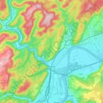
Name: Ehrang topographic map, elevation, terrain.
Average elevation: 226 m
Minimum elevation: 118 m
Maximum elevation: 412 m
Other topographic maps
Click on a map to view its topography, its elevation and its terrain.
Trèves
Allemagne > Rhénanie-Palatinat > Trèves
Trèves, Trier, Rhénanie-Palatinat, 54290, Allemagne
Average elevation: 314 m
Pfalzel
Allemagne > Rhénanie-Palatinat > Trèves
Pfalzel, Trèves, Rhénanie-Palatinat, Allemagne
Average elevation: 159 m