Geolocate

Tortosa topographic map

Click on the map to display elevation.

About this map

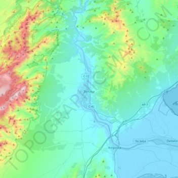
Name: Tortosa topographic map, elevation, terrain.

Location: Tortosa, Baix Ebre, Tarragona, Catalonia, Spain (40.73289 0.23281 40.89762 0.66423)

Average elevation: 250 m

Minimum elevation: -5 m

Maximum elevation: 1,428 m

Other topographic maps

Click on a map to view its topography, its elevation and its terrain.

Serra de la Mar

Spain > Catalonia > Baix Ebre > l'Ametlla de Mar

Average elevation: 170 m

Salt de la Caramella

Spain > Catalonia > Baix Ebre > Roquetes

Average elevation: 642 m

Gear up for your next adventure:

💡Compact LED Flashlight - Powerful and portable flashlight for outdoor use
🧥Thermal Fleece Jacket - Versatile insulation for changing mountain temperatures
🛌Down Sleeping Bag - Superior warmth-to-weight ratio for cold nights
🏕️Camping Hammock - Integrated protection for sleeping between trees
🚲Bike Repair Kit - Essential tools for on-trail mechanical issues

As an Amazon Associate, this site earns from qualifying purchases at no extra cost to you.