
Make a donation
Gear up for your next adventure:
As an Amazon Associate, this site earns from qualifying purchases at no extra cost to you.
Amatitlán topographic map
Click on the map to display elevation.
Make a donation
Gear up for your next adventure:
As an Amazon Associate, this site earns from qualifying purchases at no extra cost to you.
About this map
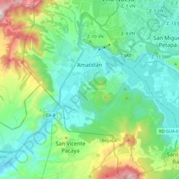
Name: Amatitlán topographic map, elevation, terrain.
Location: Amatitlán, Zona 10, Guatemala Department, Guatemala (14.38958 -90.67360 14.53000 -90.54743)
Average elevation: 1,480 m
Minimum elevation: 1,124 m
Maximum elevation: 2,606 m
Make a donation
Gear up for your next adventure:
As an Amazon Associate, this site earns from qualifying purchases at no extra cost to you.
Other topographic maps
Click on a map to view its topography, its elevation and its terrain.
Santa Catarina Pinula
Guatemala > Guatemala Department > Santa Catarina Pinula
Average elevation: 1,581 m
Colonia Villa de San Juan
Guatemala > Guatemala Department > Guatemala City
Average elevation: 1,535 m
Make a donation
Gear up for your next adventure:
As an Amazon Associate, this site earns from qualifying purchases at no extra cost to you.
Make a donation
Gear up for your next adventure:
As an Amazon Associate, this site earns from qualifying purchases at no extra cost to you.