Geolocate

Roccella Ionica topographic map

Click on the map to display elevation.

About this map

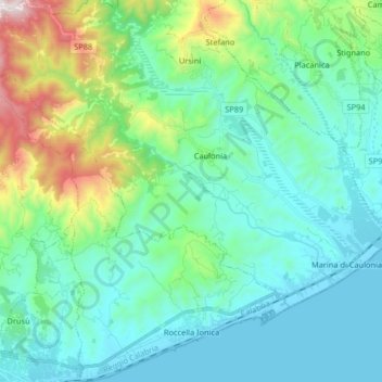
Name: Roccella Ionica topographic map, elevation, terrain.

Location: Roccella Ionica, Reggio Calabria, Calabria, 89047, Italy (38.30515 16.30151 38.43350 16.44369)

Average elevation: 237 m

Minimum elevation: -1 m

Maximum elevation: 1,163 m

Other topographic maps

Click on a map to view its topography, its elevation and its terrain.

Riace Marina

Italy > Calabria > Reggio Calabria

Average elevation: 36 m

Mandorleto

Italy > Calabria > Reggio Calabria > Locri > Moschetta

Average elevation: 19 m

Calamaci

Italy > Calabria > Reggio Calabria > Fossato

Average elevation: 715 m

Gear up for your next adventure:

👟Trail Running Shoes - Agile footwear for fast-paced topographic exploration
🧦Hiking Liner Socks - Thin base layer to prevent friction and blisters
👖Convertible Hiking Pants - Zip-off legs to adapt to changing weather conditions
🚲MTB Frame Bag - Carry tools and maps directly on your bicycle frame
🧴Waterproofing Spray - Restore the DWR coating on jackets and tents

As an Amazon Associate, this site earns from qualifying purchases at no extra cost to you.