Geolocate

Kingston topographic map

Click on the map to display elevation.

About this map

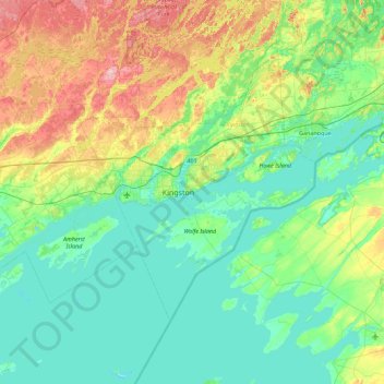
Name: Kingston topographic map, elevation, terrain.

Location: Kingston, Ontario, K7K 5J5, Canada (43.91025 -76.76890 44.55025 -76.12890)

Average elevation: 101 m

Minimum elevation: 69 m

Maximum elevation: 202 m

Ontario trails, hiking, mountain biking, running and outdoor activities

Other topographic maps

Click on a map to view its topography, its elevation and its terrain.

Belle Island

Canada > Ontario > Kingston

Average elevation: 85 m

Gear up for your next adventure:

🎒Hiking Daypack - Lightweight and durable backpacks for day trips and excursions
🧦Hiking Socks - Moisture-wicking and comfortable socks for long hikes
🛁Quick-Dry Microfiber Towel - Space-saving towel that dries rapidly on the move
🕯️Camping Lantern - Illuminates your entire campsite with high-efficiency LEDs
🥾Waterproof Hiking Boots - Essential footwear for rugged terrain and wet Canadian trails

As an Amazon Associate, this site earns from qualifying purchases at no extra cost to you.