Geolocate

Santa Rosa topographic map

Click on the map to display elevation.

About this map

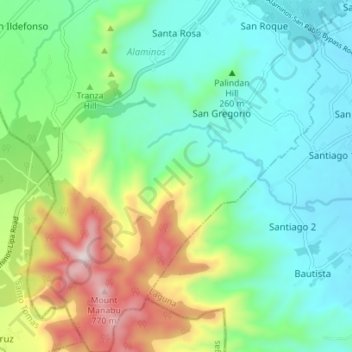
Name: Santa Rosa topographic map, elevation, terrain.

Location: Santa Rosa, Alaminos, Laguna, Calabarzon, 4001, Philippines (13.98195 121.22082 14.04990 121.26173)

Average elevation: 267 m

Minimum elevation: 65 m

Maximum elevation: 762 m

Gear up for your next adventure:

Camping Coffee Maker - Brew fresh coffee anywhere on the topographic map
🧦Merino Wool Socks - Moisture-wicking comfort for long-distance hiking
🪑Insulated Seat Pad - Protect your seat from cold rocks and wet logs
🛌Down Sleeping Bag - Superior warmth-to-weight ratio for cold nights
🧊Portable Cooler - Keep food and drinks cold during outdoor adventures

As an Amazon Associate, this site earns from qualifying purchases at no extra cost to you.