
Andahuaylas topographic map
Interactive map
Click on the map to display elevation.
About this map
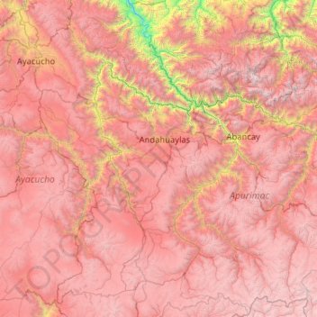
Name: Andahuaylas topographic map, elevation, terrain.
Location: Andahuaylas, Apurímac, Peru (-14.77769 -74.42854 -12.77769 -72.42854)
Average elevation: 3,635 m
Minimum elevation: 657 m
Maximum elevation: 6,035 m
Other topographic maps
Click on a map to view its topography, its elevation and its terrain.
Pumamarca
Peru > Apurímac > Tambobamba
Pumamarca, Tambobamba, Cotabambas, Apurímac, Peru
Average elevation: 3,961 m
Vilcabamba
Peru > Apurímac > Vilcabamba
Vilcabamba, Cotabambas, Apurímac, Peru
Average elevation: 3,773 m
San Juan de Miraflores
Peru > Apurímac > San Juan de Miraflores
San Juan de Miraflores, Andahuaylas, Apurímac, Peru
Average elevation: 3,428 m