Val de Bagnes topographic map
Interactive map
Click on the map to display elevation.
About this map
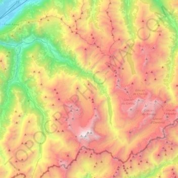
Name: Val de Bagnes topographic map, elevation, terrain.
Location: Val de Bagnes, Entremont, Wallis, 1934, Switzerland (45.89651 7.09268 46.12363 7.48829)
Average elevation: 2,321 m
Minimum elevation: 457 m
Maximum elevation: 4,282 m
Other topographic maps
Click on a map to view its topography, its elevation and its terrain.
Savu
Switzerland > Wallis > Entremont > Sembrancher
Savu, Sembrancher, Entremont, Wallis, 2303, Switzerland
Average elevation: 939 m
Maligue
Switzerland > Wallis > Entremont > La Rosière
Maligue, La Rosière, Orsières, Entremont, Wallis, 2303, Switzerland
Average elevation: 1,335 m
Mont Dolent / Monte Dolent
Switzerland > Wallis > Entremont > Orsières
Mont Dolent / Monte Dolent, Orsières, Entremont, Wallis, 2303, Switzerland
Average elevation: 3,110 m
Le Bry
Switzerland > Wallis > Entremont > Verbier
Le Bry, Fontenelle-Dessus, Verbier, Val de Bagnes, Entremont, Wallis, 1934, Switzerland
Average elevation: 1,453 m
Le Clou
Switzerland > Wallis > Entremont > La Fouly
Le Clou, La Fouly, Orsières, Entremont, Wallis, 2303, Switzerland
Average elevation: 2,009 m
Verbier
Switzerland > Wallis > Entremont
Verbier, Val de Bagnes, Entremont, Wallis, 1934, Switzerland
Average elevation: 1,626 m