
Stilton topographic map
Interactive map
Click on the map to display elevation.
About this map
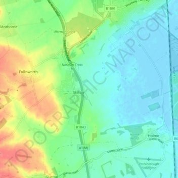
Name: Stilton topographic map, elevation, terrain.
Average elevation: 19 m
Minimum elevation: -5 m
Maximum elevation: 63 m
Other topographic maps
Click on a map to view its topography, its elevation and its terrain.
Godmanchester
Royaume-Uni > Angleterre > Cambridgeshire > Huntingdonshire > Godmanchester
Godmanchester, Huntingdonshire, Cambridgeshire, Cambridgeshire and Peterborough, Angleterre, Royaume-Uni
Average elevation: 22 m
Somersham
Royaume-Uni > Angleterre > Cambridgeshire > Huntingdonshire
Somersham, Huntingdonshire, Cambridgeshire, Cambridgeshire and Peterborough, Angleterre, PE28 3YR, Royaume-Uni
Average elevation: 9 m