
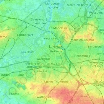
Lille topographic map
Interactive map
Click on the map to display elevation.
About this map
Name: Lille topographic map, elevation, terrain.
Average elevation: 32 m
Minimum elevation: 15 m
Maximum elevation: 62 m
Die Stadt Lille befindet sich auf einer Höhe von circa 20 m in einer Ausbuchtung des Deûle-Tals. An dieser Stelle tauchen die letzten, senonischen und turonischen Kreide-Aufschlüsse des Mélantois-Naturraums unter die Hügellandschaften der Weppes im Westen und des Barœul im Norden, die sich im landenischen Sand und ypresischen Ton gebildet haben. Die junge Sedimentdecke aus dem Pleistozän ist überall – entweder in Form von Löss auf Abhängen oder als Alluvialboden in den Talsohlen – anzutreffen.
Other topographic maps
Click on a map to view its topography, its elevation and its terrain.
Nord-Pas-de-Calais
Frankreich > Nordfrankreich > Lille > Burbure
Nord-Pas-de-Calais, Rue Gustave Nadaud, Lille Sud, Lille, Nord, Nordfrankreich, Metropolitanes Frankreich, 59037, Frankreich
Average elevation: 55 m