Geolocate

Mentakab topographic map

Click on the map to display elevation.

About this map

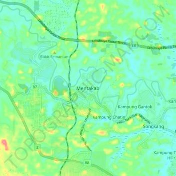
Name: Mentakab topographic map, elevation, terrain.

Location: Mentakab, Temerloh, Pahang, 28400, Malaysia (3.44645 102.31149 3.52645 102.39149)

Average elevation: 47 m

Minimum elevation: 24 m

Maximum elevation: 110 m

Other topographic maps

Click on a map to view its topography, its elevation and its terrain.

Chini Lake

Malaysia > Pahang > Kampung Tanjung Puput

Average elevation: 42 m

Chereh Reservoir

Malaysia > Pahang

Average elevation: 109 m

Tioman

Malaysia > Pahang > Tioman

Average elevation: 17 m

Gear up for your next adventure:

🌡️Emergency Mylar Blankets - Compact thermal protection for unexpected nights outdoors
🛏️Sleeping Bag - Warm and compact sleeping bags for outdoor camping
💧Hydration Bladder - Hands-free hydration solution for long treks
🕶️Polarized Sunglasses - Protect your eyes with durable polarized lenses
🚲MTB Frame Bag - Carry tools and maps directly on your bicycle frame

As an Amazon Associate, this site earns from qualifying purchases at no extra cost to you.