Geolocate

Giessen topographic map

Click on the map to display elevation.

About this map
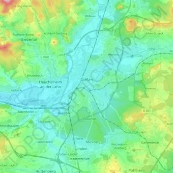
Name: Giessen topographic map, elevation, terrain.

Location: Giessen, Landkreis Gießen, Hesse, Germany (50.52633 8.55574 50.63522 8.76419)

Average elevation: 204 m

Minimum elevation: 147 m

Maximum elevation: 411 m

Other topographic maps

Click on a map to view its topography, its elevation and its terrain.

Hungen

Germany > Hesse > Landkreis Gießen

Average elevation: 160 m

Spitze

Germany > Hesse > Landkreis Gießen > Annerod

Average elevation: 249 m

Gear up for your next adventure:

☕Camping Coffee Maker - Brew fresh coffee anywhere on the topographic map
🥫Freeze-Dried Meals - Lightweight, high-calorie nutrition for multi-day treks
🚲Heavy Duty Bike Lock - Secure your bike at the trailhead or during stops
🍽️Titanium Camping Spork - Ultralight and indestructible eating utensil
❄️Traction Ice Cleats - Slip-on spikes for icy trails and winter hiking

As an Amazon Associate, this site earns from qualifying purchases at no extra cost to you.