
Bharūch topographic map
Interactive map
Click on the map to display elevation.
About this map
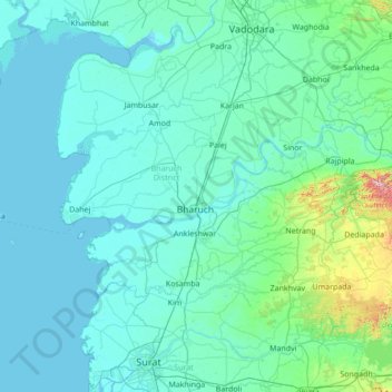
Name: Bharūch topographic map, elevation, terrain.
Location: Bharūch, Bharuch District, Guyarat, 392021, India (21.11000 72.36000 22.39000 73.64000)
Average elevation: 45 m
Minimum elevation: -3 m
Maximum elevation: 725 m
Other topographic maps
Click on a map to view its topography, its elevation and its terrain.