
Make a donation
Gear up for your next adventure:
As an Amazon Associate, this site earns from qualifying purchases at no extra cost to you.
San Isidro del Inca topographic map
Click on the map to display elevation.
Make a donation
Gear up for your next adventure:
As an Amazon Associate, this site earns from qualifying purchases at no extra cost to you.
About this map
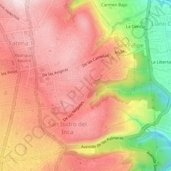
Name: San Isidro del Inca topographic map, elevation, terrain.
Average elevation: 2,806 m
Minimum elevation: 2,546 m
Maximum elevation: 2,952 m
Make a donation
Gear up for your next adventure:
As an Amazon Associate, this site earns from qualifying purchases at no extra cost to you.
Other topographic maps
Click on a map to view its topography, its elevation and its terrain.
Parque Metropolitano Guanguiltagua
Ecuador > Pichincha > Distrito Metropolitano de Quito > Quito
Average elevation: 2,848 m
Lomas de amagasi
Ecuador > Pichincha > Distrito Metropolitano de Quito > Quito
Average elevation: 2,787 m
Parque El Heraldo
Ecuador > Pichincha > Distrito Metropolitano de Quito > Quito
Average elevation: 2,818 m
Make a donation
Gear up for your next adventure:
As an Amazon Associate, this site earns from qualifying purchases at no extra cost to you.
Parque Metropolitano del Sur
Ecuador > Pichincha > Distrito Metropolitano de Quito > Quito
Average elevation: 2,952 m
Make a donation
Gear up for your next adventure:
As an Amazon Associate, this site earns from qualifying purchases at no extra cost to you.