
Pickens topographic map
Click on the map to display elevation.
About this map
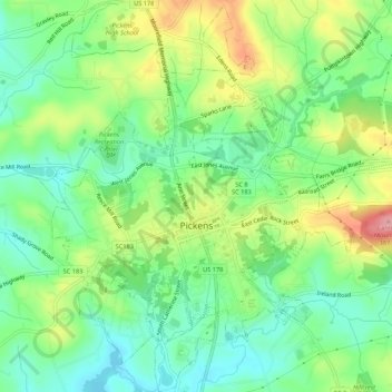
Name: Pickens topographic map, elevation, terrain.
Location: Pickens, Pickens County, South Carolina, United States (34.86469 -82.73242 34.90888 -82.68579)
Average elevation: 315 m
Minimum elevation: 270 m
Maximum elevation: 392 m
Other topographic maps
Click on a map to view its topography, its elevation and its terrain.
Dawson Park
United States > South Carolina > Pickens County > Clemson > Briarwood
Average elevation: 233 m
Sassafras Mountain
United States > South Carolina > Pickens County
The Pisgah Quadrangle topographical map, revised 1904–1905, shows the long abandoned Sassafras Gap Road to be the preferred route through to Rosman, N.C. and Brevard, N.C. at the end of the 19th century and that the existing Highway 178 was then a secondary road. This abandoned road is a short distance from…
Average elevation: 895 m
Clemson Heights
United States > South Carolina > Pickens County > Clemson > Clemson Heights
Average elevation: 217 m
Sassafras Mountain
United States > South Carolina > Pickens County
The Pisgah Quadrangle topographical map, revised 1904–1905, shows the long abandoned Sassafras Gap Road to be the preferred route through to Rosman, N.C. and Brevard, N.C. at the end of the 19th century and that the existing Highway 178 was then a secondary road. This abandoned road is a short distance from…
Average elevation: 895 m