
Make a donation
Gear up for your next adventure:
As an Amazon Associate, this site earns from qualifying purchases at no extra cost to you.
Hammonton topographic map
Click on the map to display elevation.
Make a donation
Gear up for your next adventure:
As an Amazon Associate, this site earns from qualifying purchases at no extra cost to you.
About this map
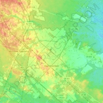
Name: Hammonton topographic map, elevation, terrain.
Location: Hammonton, Atlantic County, New Jersey, 08037, United States (39.58352 -74.85913 39.72991 -74.67579)
Average elevation: 25 m
Minimum elevation: 8 m
Maximum elevation: 47 m
Make a donation
Gear up for your next adventure:
As an Amazon Associate, this site earns from qualifying purchases at no extra cost to you.
Other topographic maps
Click on a map to view its topography, its elevation and its terrain.
Mullica Township
United States > New Jersey > Atlantic County > Mullica Township
Average elevation: 22 m
Make a donation
Gear up for your next adventure:
As an Amazon Associate, this site earns from qualifying purchases at no extra cost to you.
Make a donation
Gear up for your next adventure:
As an Amazon Associate, this site earns from qualifying purchases at no extra cost to you.
English Creek
United States > New Jersey > Atlantic County > Egg Harbor Township > English Creek
Average elevation: 5 m
Make a donation
Gear up for your next adventure:
As an Amazon Associate, this site earns from qualifying purchases at no extra cost to you.
Egg Harbor Township
United States > New Jersey > Atlantic County > Egg Harbor Township
Average elevation: 13 m