Geolocate

Crotone topographic map

Click on the map to display elevation.

About this map

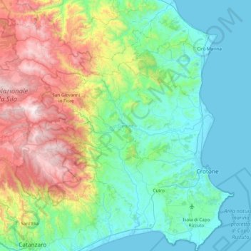
Name: Crotone topographic map, elevation, terrain.

Location: Crotone, Calabria, Italy (38.89247 16.61302 39.48244 17.20643)

Average elevation: 456 m

Minimum elevation: -1 m

Maximum elevation: 1,854 m

Other topographic maps

Click on a map to view its topography, its elevation and its terrain.

Caroni

Italy > Calabria > Vibo Valentia > Limbadi > Caroni

Average elevation: 301 m

Ferriata

Italy > Calabria > Crotone > Crotone > Ferriata

Average elevation: 10 m

Gear up for your next adventure:

🧤Rechargeable Heated Gloves - Extreme warmth for Canadian winter expeditions
🛁Quick-Dry Microfiber Towel - Space-saving towel that dries rapidly on the move
🧥Fleece Jacket - Warm and lightweight jacket for layering
🧳Compression Sacks - Maximize space in your backpack by shrinking gear
🧴Sunscreen SPF - Broad-spectrum sunscreen for outdoor activities

As an Amazon Associate, this site earns from qualifying purchases at no extra cost to you.