Geolocate

Ramat Gan topographic map

Click on the map to display elevation.

About this map
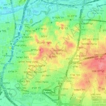
Name: Ramat Gan topographic map, elevation, terrain.

Location: Ramat Gan, Tel Aviv Subdistrict, Tel-Aviv District, Israel (32.03609 34.79912 32.10558 34.85459)

Average elevation: 35 m

Minimum elevation: 2 m

Maximum elevation: 85 m

Other topographic maps

Click on a map to view its topography, its elevation and its terrain.

Herzliya

Israel > Tel-Aviv District

Average elevation: 38 m

The Track Park

Israel > Tel-Aviv District > Tel Aviv

Average elevation: 15 m

Ayalon River

Israel > Tel-Aviv District > Tel Aviv

Average elevation: 23 m

Or Yehuda

Israel > Tel-Aviv District

Average elevation: 39 m

Herzliya

Israel > Tel-Aviv District

Average elevation: 38 m

Herzliya

Israel > Tel-Aviv District

Average elevation: 38 m

Gear up for your next adventure:

🧦Hiking Liner Socks - Thin base layer to prevent friction and blisters
🔥Emergency Fire Starter - Reliable ignition source for all weather conditions
📷Outdoor Action Camera - Capture high-elevation views and rugged adventures
💡Compact LED Flashlight - Powerful and portable flashlight for outdoor use
🧥Softshell Hiking Jacket - The perfect balance of wind protection and breathability

As an Amazon Associate, this site earns from qualifying purchases at no extra cost to you.