Geolocate

Paeroa topographic map

Click on the map to display elevation.

About this map

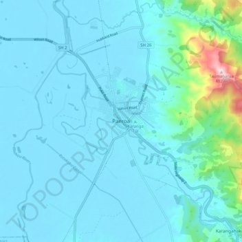
Name: Paeroa topographic map, elevation, terrain.

Location: Paeroa, Hauraki District, Waikato, 3600, New Zealand (-37.42047 175.63043 -37.34047 175.71043)

Average elevation: 52 m

Minimum elevation: 2 m

Maximum elevation: 492 m

Other topographic maps

Click on a map to view its topography, its elevation and its terrain.

Piako River

New Zealand > Waikato > Hauraki District

Average elevation: 4 m

Ohinemuri River

New Zealand > Waikato > Hauraki District

Average elevation: 197 m

Gear up for your next adventure:

🏕️Camping Hammock - Integrated protection for sleeping between trees
🎒Backpack Rain Cover - External shield to keep your entire pack dry
🦶Hiking Shoe Insoles - Added support for high arches and long days on feet
🥾Light Trekking Boots - Supportive boots for multi-day treks
🏃Hydration Running Vest - Carry water and maps close to your body for speed

As an Amazon Associate, this site earns from qualifying purchases at no extra cost to you.