
Ashgabat City topographic map
Interactive map
Click on the map to display elevation.
Ashgabat City
Ashgabat is very close to the border with Iran. It occupies a highly seismically active oasis plain bounded on the south by the foothills of the Kopet Dag mountains (Turkmen: Köpetdag) and on the north by the Karakum Desert. It is surrounded by, but not part of, Ahal Province (Turkmen: Ahal welaýaty). The highest point in the city is the 401 metres (1,316 ft) high sandhill upon which the Yyldyz Hotel was built, but most of the city lies between 200 and 255 metres (656 and 837 ft) of elevation. The Karakum Canal runs through the city.
About this map
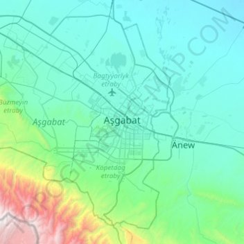
Name: Ashgabat City topographic map, elevation, terrain.
Location: Ashgabat City, Turkmenistan (37.76865 57.99227 38.10538 58.47864)
Average elevation: 467 m
Minimum elevation: 121 m
Maximum elevation: 2,763 m
Other topographic maps
Click on a map to view its topography, its elevation and its terrain.