
Thank you for supporting this site ❤️
Make a donation
Make a donation
Gear up for your next adventure:
As an Amazon Associate, this site earns from qualifying purchases at no extra cost to you.
Chiches topographic map
Click on the map to display elevation.
Thank you for supporting this site ❤️
Make a donation
Make a donation
Gear up for your next adventure:
As an Amazon Associate, this site earns from qualifying purchases at no extra cost to you.
About this map
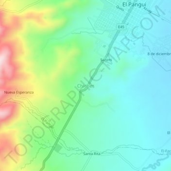
Name: Chiches topographic map, elevation, terrain.
Location: Chiches, El Pangui, Zamora Chinchipe, Ecuador (-3.66407 -78.61832 -3.62407 -78.57832)
Average elevation: 896 m
Minimum elevation: 779 m
Maximum elevation: 1,197 m
Thank you for supporting this site ❤️
Make a donation
Make a donation
Gear up for your next adventure:
As an Amazon Associate, this site earns from qualifying purchases at no extra cost to you.