Geolocate

Vukovar topographic map

Click on the map to display elevation.

Vukovar

Vukovar is located 20 km (12 mi) northeast of Vinkovci and 36 km (22 mi) southeast of Osijek, with an elevation of 108 m (354 ft). Vukovar is located on the main road D2 Osijek—Vukovar—Ilok and on the Vinkovci—Vukovar railway (and road D55).

Wikipedia (CC-BY-SA 3.0)

About this map

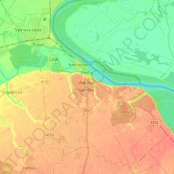
Name: Vukovar topographic map, elevation, terrain.

Location: Vukovar, Grad Vukovar, Vukovar-Srijem County, Croatia (45.28811 18.91608 45.39415 19.08341)

Average elevation: 94 m

Minimum elevation: 71 m

Maximum elevation: 114 m

Other topographic maps

Click on a map to view its topography, its elevation and its terrain.

Babina Greda

Croatia > Vukovar-Srijem County

Average elevation: 84 m

Gunja

Croatia > Vukovar-Srijem County

Average elevation: 84 m

Ilok

Croatia > Vukovar-Srijem County

Average elevation: 119 m

Orolik

Croatia > Vukovar-Srijem County

Average elevation: 96 m

Gear up for your next adventure:

🧤Insulated Winter Gloves - Heavy-duty protection for sub-zero Canadian adventures
🥤Collapsible Travel Cup - Saves space and weight in your mess kit
🥾Approach Shoes - Shoes designed for climbing approaches and rugged trails
🧶550 Survival Paracord - Versatile utility cord for emergency repairs and rigging
🥾Trail Hiking Boots - Supportive boots for rough trails

As an Amazon Associate, this site earns from qualifying purchases at no extra cost to you.