
Teslin River topographic map
Interactive map
Click on the map to display elevation.
About this map
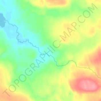
Name: Teslin River topographic map, elevation, terrain.
Location: Teslin River, Stikine Region, British Columbia, Canada (59.03291 -131.74486 59.05685 -131.66754)
Average elevation: 856 m
Minimum elevation: 818 m
Maximum elevation: 909 m
Other topographic maps
Click on a map to view its topography, its elevation and its terrain.
Gun Lake
Canada > British Columbia > Stikine Region
Gun Lake, Stikine Region, British Columbia, Canada
Average elevation: 868 m
Good Hope Lake
Canada > British Columbia > Stikine Region
Good Hope Lake, Stikine Region, British Columbia, V0C 2Z0, Canada
Average elevation: 999 m
Tulsequah
Canada > British Columbia > Stikine Region
Tulsequah, Stikine Region, British Columbia, Canada
Average elevation: 231 m
Liard River
Canada > British Columbia > Stikine Region > Lower Post
Liard River, Lower Post, Stikine Region, British Columbia, Canada
Average elevation: 669 m
Blue River
Canada > British Columbia > Stikine Region
Blue River, Stikine Region, British Columbia, Canada
Average elevation: 1,198 m
Omineca Mountains
Canada > British Columbia > Stikine Region
Omineca Mountains, Stikine Region, British Columbia, Canada
Average elevation: 1,674 m
Butte Lake
Canada > British Columbia > Stikine Region
Butte Lake, Stikine Region, British Columbia, Canada
Average elevation: 1,346 m
Hatin Lake
Canada > British Columbia > Stikine Region
Hatin Lake, Stikine Region, British Columbia, Canada
Average elevation: 973 m
Rapid River
Canada > British Columbia > Stikine Region
Rapid River, Stikine Region, British Columbia, Canada
Average elevation: 1,307 m
Teslin River
Canada > British Columbia > Stikine Region
Teslin River, Stikine Region, British Columbia, Canada
Average elevation: 827 m
Tagish Lake
Canada > British Columbia > Stikine Region
Tagish Lake, Stikine Region, British Columbia, Canada
Average elevation: 1,088 m
Cry Lake
Canada > British Columbia > Stikine Region > Area F (Dease Lake)
Cry Lake, Area F (Dease Lake), Stikine Region, British Columbia, Canada
Average elevation: 1,547 m
Cassiar
Canada > British Columbia > Stikine Region
Cassiar, Stikine Region, British Columbia, Canada
Average elevation: 1,210 m
Mount Fairweather
Canada > British Columbia > Stikine Region
Mount Fairweather, Stikine Region, British Columbia, Canada
Average elevation: 3,845 m