Geolocate

Puigcerdà topographic map

Click on the map to display elevation.

About this map

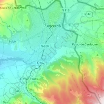
Name: Puigcerdà topographic map, elevation, terrain.

Location: Puigcerdà, Cerdanya, Girona, Catalonia, 17520, Spain (42.36193 1.89820 42.45464 1.98641)

Average elevation: 1,284 m

Minimum elevation: 1,061 m

Maximum elevation: 2,011 m

Gear up for your next adventure:

🎒Fully Waterproof Backpack - Total protection for photography gear and electronics
🕶️Polarized Sunglasses - Reduces glare from snow and water at high elevations
🥾Hiking Boots - Sturdy boots providing ankle support and traction on rugged trails
🧣Evaporative Cooling Towel - Beat the heat during intense summer climbs
🥾Mountain Hiking Boots - High-traction boots for rocky terrain

As an Amazon Associate, this site earns from qualifying purchases at no extra cost to you.