Geolocate

Dargaville topographic map

Click on the map to display elevation.

About this map

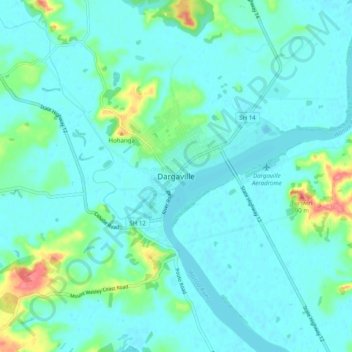
Name: Dargaville topographic map, elevation, terrain.

Location: Dargaville, Kaipara District, Northland, 0310, New Zealand (-35.98121 173.82857 -35.90121 173.90857)

Average elevation: 15 m

Minimum elevation: -6 m

Maximum elevation: 88 m

Other topographic maps

Click on a map to view its topography, its elevation and its terrain.

Wairoa River

New Zealand > Northland > Kaipara District

Average elevation: 42 m

Lake Kaiiwi

New Zealand > Northland > Kaipara District

Average elevation: 79 m

Lake Rototuna

New Zealand > Northland > Kaipara District

Average elevation: 120 m

Gear up for your next adventure:

🦯Trekking Poles - Reduced impact on joints for steep topographic climbs
Camping Tent - Weather-resistant tents suitable for 2 to 6 people
🧭GPS Handheld Device - Reliable GPS navigation for outdoor adventures
🧤Insulated Winter Gloves - Heavy-duty protection for sub-zero Canadian adventures
🧴Waterproofing Spray - Restore the DWR coating on jackets and tents

As an Amazon Associate, this site earns from qualifying purchases at no extra cost to you.