
Thank you for supporting this site ❤️
Make a donation
Make a donation
Gear up for your next adventure:
As an Amazon Associate, this site earns from qualifying purchases at no extra cost to you.
Wellersen topographic map
Click on the map to display elevation.
Thank you for supporting this site ❤️
Make a donation
Make a donation
Gear up for your next adventure:
As an Amazon Associate, this site earns from qualifying purchases at no extra cost to you.
Wellersen
Wellersen liegt an der Dieße. Der Ort liegt am Nordrand der Ahlsburg (Höhenzug) am Westrand des Leinegrabens. Am Ortsrand liegt eine Verwerfung von Liaskalk oberflächennah, so dass hier Ammoniten gefunden worden sind.
Thank you for supporting this site ❤️
Make a donation
Make a donation
Gear up for your next adventure:
As an Amazon Associate, this site earns from qualifying purchases at no extra cost to you.
About this map
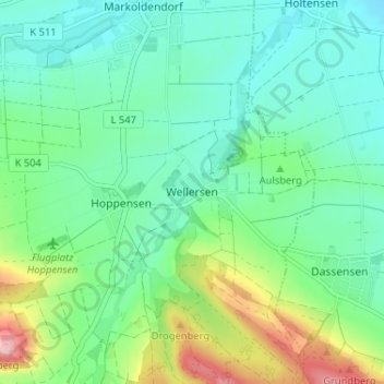
Name: Wellersen topographic map, elevation, terrain.
Average elevation: 168 m
Minimum elevation: 123 m
Maximum elevation: 291 m
Thank you for supporting this site ❤️
Make a donation
Make a donation
Gear up for your next adventure:
As an Amazon Associate, this site earns from qualifying purchases at no extra cost to you.