
Make a donation
Gear up for your next adventure:
As an Amazon Associate, this site earns from qualifying purchases at no extra cost to you.
Orgelet topographic map
Click on the map to display elevation.
Make a donation
Gear up for your next adventure:
As an Amazon Associate, this site earns from qualifying purchases at no extra cost to you.
About this map
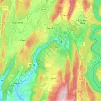
Name: Orgelet topographic map, elevation, terrain.
Average elevation: 507 m
Minimum elevation: 359 m
Maximum elevation: 740 m
Make a donation
Gear up for your next adventure:
As an Amazon Associate, this site earns from qualifying purchases at no extra cost to you.
Other topographic maps
Click on a map to view its topography, its elevation and its terrain.
Make a donation
Gear up for your next adventure:
As an Amazon Associate, this site earns from qualifying purchases at no extra cost to you.
La Vie Neuve
Frankrijk > Bourgondië-Franche-Comté > Jura > Septmoncel les Molunes
Average elevation: 961 m
Lieffenans
Frankrijk > Bourgondië-Franche-Comté > Jura > Charézier > Lieffenans
Average elevation: 482 m
Make a donation
Gear up for your next adventure:
As an Amazon Associate, this site earns from qualifying purchases at no extra cost to you.