
Thank you for supporting this site ❤️
Make a donation
Make a donation
Gear up for your next adventure:
As an Amazon Associate, this site earns from qualifying purchases at no extra cost to you.
Valdeteja topographic map
Click on the map to display elevation.
Thank you for supporting this site ❤️
Make a donation
Make a donation
Gear up for your next adventure:
As an Amazon Associate, this site earns from qualifying purchases at no extra cost to you.
About this map
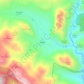
Name: Valdeteja topographic map, elevation, terrain.
Location: Valdeteja, Valdelugueros, León, Castilla y León, España (42.90918 -5.44631 42.94918 -5.40631)
Average elevation: 1,406 m
Minimum elevation: 1,084 m
Maximum elevation: 1,891 m
Thank you for supporting this site ❤️
Make a donation
Make a donation
Gear up for your next adventure:
As an Amazon Associate, this site earns from qualifying purchases at no extra cost to you.