Geolocate

Pandharpur topographic map

Click on the map to display elevation.

About this map

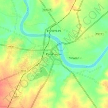
Name: Pandharpur topographic map, elevation, terrain.

Location: Pandharpur, Solapur, Maharashtra, 413300, India (17.63782 75.29410 17.71782 75.37410)

Average elevation: 459 m

Minimum elevation: 434 m

Maximum elevation: 488 m

Gear up for your next adventure:

🪑Insulated Seat Pad - Protect your seat from cold rocks and wet logs
🥾Trail Hiking Shoes - Durable shoes designed for rugged trails
🧭Orienteering Kit - Tools for map reading and navigation in the wild
💡Portable Camping Lamp - Rechargeable lamp for campsite lighting
🔦LED Headtorch - Bright and durable light for night activities

As an Amazon Associate, this site earns from qualifying purchases at no extra cost to you.