
Thank you for supporting this site ❤️
Make a donation
Make a donation
Gear up for your next adventure:
As an Amazon Associate, this site earns from qualifying purchases at no extra cost to you.
Canutal topographic map
Click on the map to display elevation.
Thank you for supporting this site ❤️
Make a donation
Make a donation
Gear up for your next adventure:
As an Amazon Associate, this site earns from qualifying purchases at no extra cost to you.
About this map
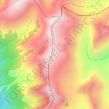
Name: Canutal topographic map, elevation, terrain.
Location: Canutal, Valladolid, Palanda, Zamora Chinchipe, Ecuador (-4.51751 -79.32664 -4.51741 -79.32654)
Average elevation: 3,409 m
Minimum elevation: 2,919 m
Maximum elevation: 3,654 m
Thank you for supporting this site ❤️
Make a donation
Make a donation
Gear up for your next adventure:
As an Amazon Associate, this site earns from qualifying purchases at no extra cost to you.