
Make a donation
Gear up for your next adventure:
As an Amazon Associate, this site earns from qualifying purchases at no extra cost to you.
Sennwald topographic map
Click on the map to display elevation.
Make a donation
Gear up for your next adventure:
As an Amazon Associate, this site earns from qualifying purchases at no extra cost to you.
About this map
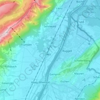
Name: Sennwald topographic map, elevation, terrain.
Location: Sennwald, Wahlkreis Werdenberg, St. Gallen, Schweiz (47.19794 9.40012 47.28302 9.53038)
Average elevation: 615 m
Minimum elevation: 421 m
Maximum elevation: 1,930 m
Make a donation
Gear up for your next adventure:
As an Amazon Associate, this site earns from qualifying purchases at no extra cost to you.
Other topographic maps
Click on a map to view its topography, its elevation and its terrain.
Make a donation
Gear up for your next adventure:
As an Amazon Associate, this site earns from qualifying purchases at no extra cost to you.
Make a donation
Gear up for your next adventure:
As an Amazon Associate, this site earns from qualifying purchases at no extra cost to you.
Gamsberg
Schweiz > St. Gallen > Wahlkreis Werdenberg > Grabs
Der Gamsberg ist ein Berg in der Ostschweiz mit einer Höhe von 2385 m ü. M. Von den Einheimischen wird er auch Gemsler genannt. Er ist der höchste Punkt des Massivs zwischen Walensee und Toggenburg und damit auch der politischen Gemeinde Grabs im Kanton St. Gallen.
Average elevation: 1,836 m