
Thank you for supporting this site ❤️
Make a donation
Make a donation
Gear up for your next adventure:
As an Amazon Associate, this site earns from qualifying purchases at no extra cost to you.
Zacapu topographic map
Click on the map to display elevation.
Thank you for supporting this site ❤️
Make a donation
Make a donation
Gear up for your next adventure:
As an Amazon Associate, this site earns from qualifying purchases at no extra cost to you.
About this map
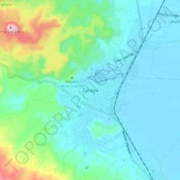
Name: Zacapu topographic map, elevation, terrain.
Location: Zacapu, Michoacán, 58600, Mexico (19.65841 -101.95251 19.97841 -101.63251)
Average elevation: 2,262 m
Minimum elevation: 1,786 m
Maximum elevation: 3,374 m
Thank you for supporting this site ❤️
Make a donation
Make a donation
Gear up for your next adventure:
As an Amazon Associate, this site earns from qualifying purchases at no extra cost to you.