
Make a donation
Gear up for your next adventure:
As an Amazon Associate, this site earns from qualifying purchases at no extra cost to you.
Hettenrodt topographic map
Click on the map to display elevation.
Make a donation
Gear up for your next adventure:
As an Amazon Associate, this site earns from qualifying purchases at no extra cost to you.
Hettenrodt
Der Ort liegt an der Ostseite eines Höhenzuges zwischen Idarbach und Siesbach im vorderen Hunsrück und grenzt direkt an die Stadt Idar-Oberstein. Die gesamte Gemarkung umfasst 532 ha, davon sind etwa 120 ha Staatswald. Die Ortslage selbst hat eine Fläche von 29 ha. Die Ortsgemarkung besitzt eine unförmige, bizarre Struktur. Daraus resultiert der recht große Grenzumfang von ungefähr 20 km. Der Ortsmittelpunkt hat eine Höhe von 410 m ü. NHN, der höchste Punkt mit 623 m ü. NHN ist die Festung bei Kirschweiler.
Make a donation
Gear up for your next adventure:
As an Amazon Associate, this site earns from qualifying purchases at no extra cost to you.
About this map
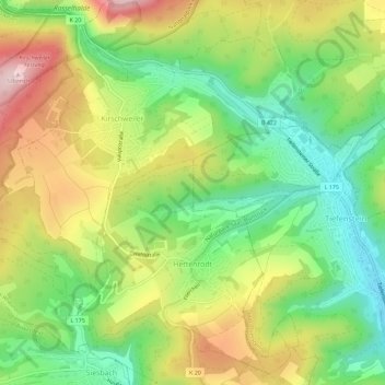
Name: Hettenrodt topographic map, elevation, terrain.
Average elevation: 438 m
Minimum elevation: 310 m
Maximum elevation: 605 m
Make a donation
Gear up for your next adventure:
As an Amazon Associate, this site earns from qualifying purchases at no extra cost to you.