
Kiten topographic map
Interactive map
Click on the map to display elevation.
About this map
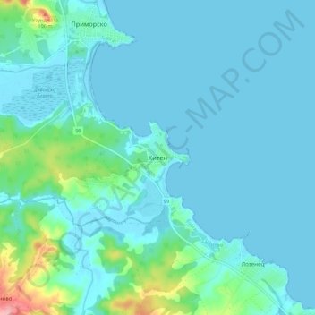
Name: Kiten topographic map, elevation, terrain.
Average elevation: 17 m
Minimum elevation: -1 m
Maximum elevation: 129 m
Other topographic maps
Click on a map to view its topography, its elevation and its terrain.
Municipalité de Bourgas
Municipalité de Bourgas, Oblast de Bourgas, Bulgarie
Average elevation: 63 m
Municipalité de Rouen
Municipalité de Rouen, Oblast de Bourgas, Bulgarie
Average elevation: 258 m
Municipalité de Sozopol
Municipalité de Sozopol, Oblast de Bourgas, Bulgarie
Average elevation: 68 m
Nessebar
Nessebar, Municipalité de Nessebar, Oblast de Bourgas, 8230, Bulgarie
Average elevation: 4 m
Gyoulyovtsa
Gyoulyovtsa, Municipalité de Nessebar, Oblast de Bourgas, 8249, Bulgarie
Average elevation: 68 m
Panitsovo
Panitsovo, Municipalité de Nessebar, Oblast de Bourgas, 8254, Bulgarie
Average elevation: 265 m