Geolocate

Dunlap topographic map

Click on the map to display elevation.

About this map

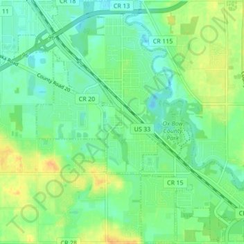
Name: Dunlap topographic map, elevation, terrain.

Location: Dunlap, Elkhart County, Indiana, United States (41.60852 -85.94562 41.65954 -85.88111)

Average elevation: 239 m

Minimum elevation: 228 m

Maximum elevation: 256 m

Other topographic maps

Click on a map to view its topography, its elevation and its terrain.

Vistula

United States > Indiana > Elkhart County

Average elevation: 243 m

Benton

United States > Indiana > Elkhart County

Average elevation: 257 m

Elkhart

United States > Indiana > Elkhart County > Elkhart

Average elevation: 247 m

Gear up for your next adventure:

🧴Bear Spray Holster - Quick-access carry for essential Canadian wilderness safety
🦶Anti-Blister Balm - Prevents friction and hotspots during long ascents
🎒Hiking Daypack - Lightweight and durable backpacks for day trips and excursions
Camping Essentials - All-in-one gear for a comfortable camping trip
🔦UV Flashlight - Detect minerals or specific insects in the dark

As an Amazon Associate, this site earns from qualifying purchases at no extra cost to you.