Geolocate

Taylor Corners topographic map

Click on the map to display elevation.

About this map

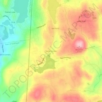
Name: Taylor Corners topographic map, elevation, terrain.

Location: Taylor Corners, New Fairfield, Western Connecticut Planning Region, Connecticut, 06812, United States (41.42676 -73.54485 41.46676 -73.50485)

Average elevation: 226 m

Minimum elevation: 125 m

Maximum elevation: 314 m

Other topographic maps

Click on a map to view its topography, its elevation and its terrain.

Gear up for your next adventure:

🧴Sunscreen SPF - Broad-spectrum sunscreen for outdoor activities
🔭Outdoor Binoculars - Lightweight binoculars for birdwatching and hiking
🧥Packable Rain Jacket - Breathable waterproof layer for unpredictable weather
🎒Hiking Daypack - Lightweight and durable backpacks for day trips and excursions
🕶️Polarized Sunglasses - Reduces glare from snow and water at high elevations

As an Amazon Associate, this site earns from qualifying purchases at no extra cost to you.