
Make a donation
Gear up for your next adventure:
As an Amazon Associate, this site earns from qualifying purchases at no extra cost to you.
Finkenbach topographic map
Click on the map to display elevation.
Make a donation
Gear up for your next adventure:
As an Amazon Associate, this site earns from qualifying purchases at no extra cost to you.
Finkenbach
Zuletzt erreicht er die Stadt Hirschhorn, wo der Ulfenbach fast im rechten Winkel von rechts auf ihn trifft und sich mit ihm zum Laxbach auf einer Höhe von 120 m ü. NHN vereint. Dieser mündet nach etwa 700 m eigenen Laufs in den Neckar.
Make a donation
Gear up for your next adventure:
As an Amazon Associate, this site earns from qualifying purchases at no extra cost to you.
About this map
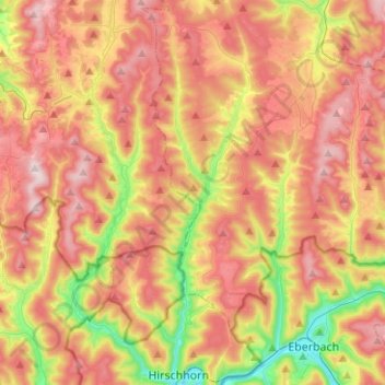
Name: Finkenbach topographic map, elevation, terrain.
Average elevation: 380 m
Minimum elevation: 119 m
Maximum elevation: 603 m
Make a donation
Gear up for your next adventure:
As an Amazon Associate, this site earns from qualifying purchases at no extra cost to you.