Geolocate

Hythe topographic map

Click on the map to display elevation.

About this map

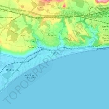
Name: Hythe topographic map, elevation, terrain.

Location: Hythe, Folkestone and Hythe District, Kent, England, United Kingdom (51.04664 1.02214 51.08961 1.12895)

Average elevation: 32 m

Minimum elevation: -2 m

Maximum elevation: 165 m

Other topographic maps

Click on a map to view its topography, its elevation and its terrain.

Gear up for your next adventure:

🧰Emergency Multi-Tool - Compact multi-tool for outdoor survival
🥾Light Hiking Boots - Lightweight and comfortable boots for day hikes
🧥Waterproof Pants - Keep dry during rainy hiking conditions
🥾Hiking Shorts - Breathable shorts suitable for summer hikes
🥾Hiking Gaiters - Protect legs and shoes from mud, snow, and debris

As an Amazon Associate, this site earns from qualifying purchases at no extra cost to you.