Geolocate

Oneida topographic map

Interactive map

Click on the map to display elevation.

About this map

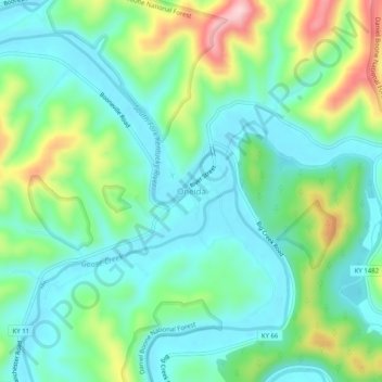
Name: Oneida topographic map, elevation, terrain.

Location: Oneida, Clay County, Kentucky, United States (37.24953 -83.66908 37.28953 -83.62908)

Average elevation: 297 m

Minimum elevation: 227 m

Maximum elevation: 477 m

Other topographic maps

Click on a map to view its topography, its elevation and its terrain.

Littleton

United States > Kentucky > Clay County

Littleton, Clay County, Kentucky, 40962, United States

Average elevation: 315 m

Sextons Creek

United States > Kentucky > Clay County

Sextons Creek, Clay County, Kentucky, 40983, United States

Average elevation: 311 m

Big Creek

United States > Kentucky > Clay County

Big Creek, Clay County, Kentucky, 40914, United States

Average elevation: 354 m

Fall Rock

United States > Kentucky > Clay County

Fall Rock, Clay County, Kentucky, United States

Average elevation: 344 m

Manchester

United States > Kentucky > Clay County

Manchester, Clay County, Kentucky, 40962, United States

Average elevation: 315 m

Vine

United States > Kentucky > Clay County

Vine, Clay County, Kentucky, United States

Average elevation: 335 m