Geolocate

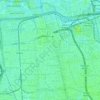
Kuningan Timur topographic map

Click on the map to display elevation.

About this map

Name: Kuningan Timur topographic map, elevation, terrain.

Location: Kuningan Timur, Setiabudi, South Jakarta, Special Capital Region of Jakarta, Indonesia (-6.24090 106.82083 -6.22402 106.83680)

Average elevation: 18 m

Minimum elevation: 6 m

Maximum elevation: 43 m

Other topographic maps

Click on a map to view its topography, its elevation and its terrain.

Gear up for your next adventure:

🧢Sun Protection Cap - Breathable cap to protect from sun exposure
🧥Softshell Jacket - Windproof and breathable jacket for hiking
🧥Ultralight Puffy Jacket - Maximum warmth that packs down to the size of an orange
💡Solar Camping Lamp - Eco-friendly lighting for campsites
🔦LED Headlamp - Hands-free lighting for early morning starts or late finishes

As an Amazon Associate, this site earns from qualifying purchases at no extra cost to you.