Geolocate

Pisgah topographic map

Click on the map to display elevation.

About this map

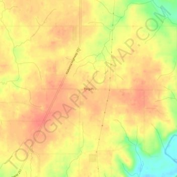
Name: Pisgah topographic map, elevation, terrain.

Location: Pisgah, Limestone County, Alabama, United States (34.86981 -86.83722 34.90981 -86.79722)

Average elevation: 253 m

Minimum elevation: 217 m

Maximum elevation: 268 m

Other topographic maps

Click on a map to view its topography, its elevation and its terrain.

Athens

United States > Alabama > Limestone County

Average elevation: 204 m

Elkmont

United States > Alabama > Limestone County

Average elevation: 249 m

Elkmont

United States > Alabama > Limestone County

Average elevation: 249 m

Athens

United States > Alabama > Limestone County

Average elevation: 204 m

Gear up for your next adventure:

🥾Hiking Shoes - Durable and comfortable shoes for trail hiking
🧥Packable Rain Jacket - Breathable waterproof layer for unpredictable weather
🥾Trail Hiking Socks - Comfortable socks to prevent blisters and fatigue
🧥Ultralight Puffy Jacket - Maximum warmth that packs down to the size of an orange
Camping Tent - Weather-resistant tents suitable for 2 to 6 people

As an Amazon Associate, this site earns from qualifying purchases at no extra cost to you.