Geolocate

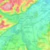
Gannertshofen topographic map

Click on the map to display elevation.

About this map

Name: Gannertshofen topographic map, elevation, terrain.

Location: Gannertshofen, Buch, Buch (VGem), Landkreis Neu-Ulm, Beieren, 89290, Duitsland (48.23940 10.15157 48.27940 10.19157)

Average elevation: 529 m

Minimum elevation: 500 m

Maximum elevation: 571 m

Other topographic maps

Click on a map to view its topography, its elevation and its terrain.
Neu-Ulm

Duitsland > Beieren > Landkreis Neu-Ulm

Average elevation: 498 m

Gear up for your next adventure:

🧢Outdoor Visor - Breathable visor for sunny hikes
💡LED Headlamp - Hands-free illumination for night hiking and camping
🎒Fully Waterproof Backpack - Total protection for photography gear and electronics
🧥Thermal Layer - Insulating layer for cold outdoor conditions
👟Leg Gaiters - Keep debris, mud, and snow out of your boots

As an Amazon Associate, this site earns from qualifying purchases at no extra cost to you.